Picture 1 of 7


Picture 1 of 7


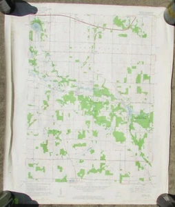
1958 Donaldson, IN Quadrangle Topographic Map - Marshall County, IN - 1:24,000

US $15.00
ApproximatelyEUR 13.48
Condition:
“Map is in good condition. Please see scans as they are a part of the description.”
Postage:
US $7.00 (approx EUR 6.29) USPS Ground Advantage®.
Located in: Jesup, Georgia, United States
Delivery:
Estimated between Tue, 24 Sep and Sat, 28 Sep to 43230
Returns:
14 days return. Buyer pays for return postage.
Payments:
Shop with confidence
Seller assumes all responsibility for this listing.
eBay item number:145172024654
Item specifics
- Seller notes
- “Map is in good condition. Please see scans as they are a part of the description.”
- Date Range
- 1950-1959
- Type
- Topographical Map
- US State
- Indiana
- Format
- Topographic
- Year
- 1958
- Original/Reproduction
- Antique Original
- Cartographer/Publisher
- USGS
- City
- Donaldson Quadrangle - Marshall County, Indiana
- Country/Region
- United States of America
Item description from the seller

Popular categories from this shop
Registered as a private seller
Thereby, consumer rights stemming from EU consumer protection law do not apply. eBay buyer protection still applies to most purchases.
Seller Feedback (3,456)
- w***d (7501)- Feedback left by buyer.Past monthVerified purchasenice thanks
- n***c (650)- Feedback left by buyer.Past monthVerified purchaseBeautiful! Just as described and arrived quickly. Excellent packaging
- u***s (1432)- Feedback left by buyer.Past monthVerified purchaseExcellent communication! I love getting proactive updates on shipping. And speaking of shipping, sent in a bubble mailer so the book and pamphlet arrived safely. Thank you! Item exactly as described. A perfect purchase, I'm so pleased. Would happily buy again from this great seller!!
More to explore:
- Antique County Maps,
- County Durham County Map Antique Europe Atlas Maps,
- County Map Antique Folding Maps,
- Norfolk Antique County Maps,
- County Durham Antique Europe County Maps,
- Somerset Antique County Maps,
- Herman Moll Antique County Maps,
- Emanuel Bowen Antique County Maps,
- Thomas Kitchin Antique County Maps,
- Derbyshire Antique Europe County Maps