Picture 1 of 4


Gallery
Picture 1 of 4


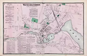
1870 WINCHENDON Township Plat Map WORCESTER County Massachusetts (22X14)
US $34.88
ApproximatelyEUR 30.88
or Best Offer
Condition:
- Buy it now1870 WINCHENDON Township Plat Map WORCESTER County Massachusetts (22X14)
Oops! Looks like we're having trouble connecting to our server.
Refresh your browser window to try again.
Postage:
Free USPS Ground Advantage®.
Located in: Monroe, Georgia, United States
Delivery:
Estimated between Thu, 8 May and Tue, 13 May to 43230
Returns:
30 days return. Seller pays for return postage.
Payments:
Shop with confidence
Seller assumes all responsibility for this listing.
eBay item number:226686361186
Item specifics
- US State
- Massachusetts
- Printing Technique
- Lithography
- Color
- Original hand-coloring
- Cartographer/Publisher
- F. W. Beers & Co.
- City
- Winchendon
- Date Range
- 1800-1899
- Type
- Plat Map
- Format
- Atlas Map
- Title page
- Shown for reference only, a copy can be provided, ask at checkout
- Year
- 1870
- Original/Reproduction
- Antique Original
- Atlas Source
- Atlas of Worcester County Massachusetts, 1870
- Country/Region
- United States of America
Item description from the seller
About this seller

SELSA84 MAPS ANTIQUE MAPS & PRINTS
100% positive Feedback•15K items sold
Registered as a private sellerThereby, consumer rights stemming from EU consumer protection law do not apply. eBay buyer protection still applies to most purchases.
Seller Feedback (6,265)
- b***0 (9)- Feedback left by buyer.Past monthVerified purchaseItem packaged very carefully and is exactly as described. Shipping time from order to shipment was also very good.
- a***e (238)- Feedback left by buyer.Past monthVerified purchaseNice map, and arrived as described. Well packed.
- a***w (949)- Feedback left by buyer.Past monthVerified purchaseGood people
More to explore:
- Antique County Maps,
- Antique North American Maps & Atlases Massachusetts,
- County Durham County Map Antique Europe Atlas Maps,
- County Map Antique Folding Maps,
- Somerset Antique County Maps,
- Norfolk Antique County Maps,
- John Speed Antique County Maps,
- Antique Worcestershire County Maps,
- John Cary Antique County Maps,
- Yorkshire Antique Europe County Maps
SELSA84 MAPS ANTIQUE MAPS & PRINTS
100% positive Feedback•15K items sold
Registered as a private sellerThereby, consumer rights stemming from EU consumer protection law do not apply. eBay buyer protection still applies to most purchases.
Seller Feedback (6,265)
- b***0 (9)- Feedback left by buyer.Past monthVerified purchaseItem packaged very carefully and is exactly as described. Shipping time from order to shipment was also very good.
- a***e (238)- Feedback left by buyer.Past monthVerified purchaseNice map, and arrived as described. Well packed.
- a***w (949)- Feedback left by buyer.Past monthVerified purchaseGood people