Picture 1 of 6


Gallery
Picture 1 of 6


Have one to sell?
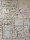
1899 SPRINGFIELD MA SOUTH END: MILL RIVER TO FOREST PARK & PARK AVE ATLAS MAP
US $49.95
ApproximatelyEUR 43.19
Condition:
“24x36 high quality high resolution reproduction on 70 lb. thick stock paper, Other sizes available ”... Read moreAbout condition
10 available
- Buy it now1899 SPRINGFIELD MA SOUTH END: MILL RIVER TO FOREST PARK & PARK AVE ATLAS MAP
Oops! Looks like we're having trouble connecting to our server.
Refresh your browser window to try again.
Postage:
US $21.15 (approx EUR 18.29) USPS Ground Advantage®.
Located in: Floral Park, New York, United States
Delivery:
Estimated between Mon, 17 Nov and Thu, 20 Nov to 94104
Returns:
14 days return. Buyer pays for return postage. If you use an eBay delivery label, it will be deducted from your refund amount.
Payments:
Shop with confidence
Seller assumes all responsibility for this listing.
eBay item number:235213309986
Item specifics
- Seller notes
- Date Range
- 1800-1899
- Type
- City Map
- US State
- Massachusetts
- Format
- Atlas Map
- Year
- 1899
- Cartographer/Publisher
- L.J. RICHARDS
- Original/Reproduction
- Vintage Reproduction
- Country/Region
- United States of America
Item description from the seller
Seller business information
Seller Feedback (2,652)
- c***n (1612)- Feedback left by buyer.Past 6 monthsVerified purchaseI have totally enjoyed the entire purchasing process and a Big Great Reason for this is i had a very professional TRANSACTION with this Super Seller !!! No misunderstanding on any part of the buyer and/or the Seller !! Nice smooth clear transaction ,the experience with mschalfer was Great, right on Point and I will absolutely do more business with these Folks again ! Item was delivered promptly damage free,and is exactly the very same item i had ordered !!!! Great Business
- n***n (1305)- Feedback left by buyer.Past 6 monthsVerified purchaseAccurate description, good packaging, prompt delivery: Excellent!
- y***r (124)- Feedback left by buyer.Past 6 monthsVerified purchaseAlthough shipping took longer than expected, it was very well packaged and the item was very well described. It is a wonderful piece of our family history1913 PHILADELPHIA, PENNSYLVANIA TACONY CREEK PARK CEDAR GROVE MILLS ATLAS MAP (#233182583716)
More to explore:
- 1800-1899 Date Range Antique South America Atlas Maps,
- Antique South America Atlas Maps,
- Political Map Antique South America Atlas Maps,
- Topographical Map Antique South America Atlas Maps,
- Lithography Antique South America Atlas Maps,
- Antique Original Antique South America Atlas Maps,
- 1800-1899 Date Range Thematic Map Antique Atlas Maps,
- 1800-1899 Date Range World Atlas Antique Europe Atlas Maps,
- 1800-1899 Date Range Political Map Antique World Atlas Maps,
- Atlas Map 1800-1899 Date Range Physical Map Antique Maps, Atlases & Globes