Picture 1 of 13


Gallery
Picture 1 of 13


Have one to sell?
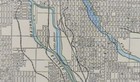
Vintage 1901 DENVER COLORADO Map 14"x11" ~ Old Antique Original CURTIS PARK

US $23.07
ApproximatelyEUR 19.82
or Best Offer
Was US $34.95 (34% off)
Condition:
- Buy it nowVintage 1901 DENVER COLORADO Map 14"x11" ~ Old Antique Original CURTIS PARK
Oops! Looks like we're having trouble connecting to our server.
Refresh your browser window to try again.
Postage:
Free USPS Ground Advantage®.
Located in: Augusta, Wisconsin, United States
Delivery:
Estimated between Wed, 13 Aug and Mon, 18 Aug to 94104
Returns:
30 days return. Buyer pays for return postage. If you use an eBay delivery label, it will be deducted from your refund amount.
Payments:
Shop with confidence
Seller assumes all responsibility for this listing.
eBay item number:235540374806
Item specifics
- Date Range
- 1900-1909
- Type
- Beautiful antique original map suitable for framing
- Format
- Atlas Map
- US State
- Colorado
- Year
- 1901
- Cartographer/Publisher
- George Cram
- Original/Reproduction
- Antique Original
- City
- Denver
- Country/Region
- United States of America
Item description from the seller
About this seller

Uncommon_maps
100% positive Feedback•7.7K items sold
Registered as a private sellerThereby, consumer rights stemming from EU consumer protection law do not apply. eBay buyer protection still applies to most purchases.
Seller Feedback (2,431)
- s***a (859)- Feedback left by buyer.Past monthVerified purchaseVery helpful seller
- 2***1 (600)- Feedback left by buyer.Past monthVerified purchaseNice map
- y***r (140)- Feedback left by buyer.Past monthVerified purchaseExcellent experience
More to explore:
- Colorado Antique Original Antique North America Maps & Atlases,
- Vintage Original Antique School Maps,
- Vintage Original Antique City Maps,
- Vintage Original Antique Nautical Maps,
- Vintage Original Antique Sheet Maps,
- Vintage Original Nautical Map Antique Sheet Maps,
- Vintage Original Antique Maps, Atlases & Globes,
- Vintage Original Antique Europe Folding Maps,
- Vintage Original Antique Asia Political Maps,
- Vintage Original Antique Europe Physical Maps
Uncommon_maps
100% positive Feedback•7.7K items sold
Registered as a private sellerThereby, consumer rights stemming from EU consumer protection law do not apply. eBay buyer protection still applies to most purchases.
Seller Feedback (2,431)
- s***a (859)- Feedback left by buyer.Past monthVerified purchaseVery helpful seller
- 2***1 (600)- Feedback left by buyer.Past monthVerified purchaseNice map
- y***r (140)- Feedback left by buyer.Past monthVerified purchaseExcellent experience