Picture 1 of 3


Gallery
Picture 1 of 3


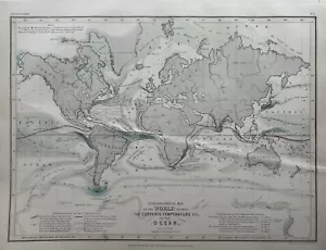
1850 Hydrographic World Ocean Currents Temperatures Hand Coloured Map Petermann
£24.99
ApproximatelyEUR 29.73
or Best Offer
Condition:
“The map is in good condition except for some creasing.”
- Buy it now1850 Hydrographic World Ocean Currents Temperatures Hand Coloured Map Petermann
Oops! Looks like we're having trouble connecting to our server.
Refresh your browser window to try again.
Postage:
£12.00 (approx EUR 14.28) Parcelforce Global Express.
Located in: Manchester, United Kingdom
Delivery:
Estimated between Fri, 23 May and Thu, 29 May to 43230
Returns:
60 days return. Seller pays for return postage.
Payments:
Shop with confidence
Seller assumes all responsibility for this listing.
eBay item number:256927636922
Item specifics
- Seller notes
- “The map is in good condition except for some creasing.”
- Date Range
- 1800-1899
- Antique
- Yes
- Type
- Ocean Current Map
- Format
- Atlas Map
- Year
- 1850
- Era
- 1800s
- Map View
- World
- Original/Reproduction
- Antique Original
- Cartographer/Publisher
- Augustus Petermann
Item description from the seller
Seller business information

Seller Feedback (5,075)
- o***h (65)- Feedback left by buyer.Past monthVerified purchaseJust as described. Fast shipping and excellent packaging. Thank you
- Automatyczna opinia eBay- Feedback left by buyer.Past monthZamówienie zostało zrealizowane – ze śledzeniem i na czas
- Automatyczna opinia eBay- Feedback left by buyer.Past monthZamówienie zostało zrealizowane – ze śledzeniem i na czas
More to explore:
- World Antique World Ocean Current Maps,
- Antique World Ocean Current Maps,
- Antique Ocean Current Maps,
- World 1800-1899 Date Range Antique World Ocean Current Maps,
- 1800-1899 Date Range Antique World Ocean Current Maps,
- Antique World Maps & Atlases,
- Antique World Wall Maps,
- Antique World Atlas Maps,
- Atlas Antique World Maps & Atlases,
- Antique World Railroad Maps
Seller Feedback (5,075)
- o***h (65)- Feedback left by buyer.Past monthVerified purchaseJust as described. Fast shipping and excellent packaging. Thank you
- Automatyczna opinia eBay- Feedback left by buyer.Past monthZamówienie zostało zrealizowane – ze śledzeniem i na czas
- Automatyczna opinia eBay- Feedback left by buyer.Past monthZamówienie zostało zrealizowane – ze śledzeniem i na czas