Picture 1 of 3


Gallery
Picture 1 of 3


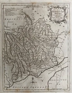
1763 Antique map - Monmouthshire - by Thomas Kitchin
£24.99
ApproximatelyEUR 29.38
Condition:
“Very good. Suitable for framing. Please check the scan for any blemishes prior to making your ”... Read moreAbout condition
- Buy it now1763 Antique map - Monmouthshire - by Thomas Kitchin
Oops! Looks like we're having trouble connecting to our server.
Refresh your browser window to try again.
Postage:
£5.20 (approx EUR 6.11) Royal Mail International Standard.
Located in: Marlow, United Kingdom
Delivery:
Estimated between Sat, 10 May and Fri, 23 May to 43230
Returns:
30 days return. Buyer pays for return postage. If you use an eBay delivery label, it will be deducted from your refund amount.
Payments:
Shop with confidence
Seller assumes all responsibility for this listing.
eBay item number:295428719466
Item specifics
- Seller notes
- Date Range
- 1700-1799
- Type
- County Map
- Printing Technique
- Copper Plate
- Format
- Atlas Map
- Year
- 1763
- Era
- 1700s
- Cartographer/Publisher
- Thomas Kitchin
- Original/Reproduction
- Antique Original
- Country/Region
- United Kingdom
- County
- Monmouthshire
Item description from the seller
Seller business information

Seller Feedback (13,991)
- 7***l (4588)- Feedback left by buyer.Past monthVerified purchaseI love my purchase. Thanks
- 3***9 (4)- Feedback left by buyer.Past monthVerified purchaseAll good - lovely etching!
- g***a (309)- Feedback left by buyer.Past monthVerified purchaseExcellent, thanks very much I’m very pleased
More to explore:
- Thomas Kitchin Antique County Maps,
- Thomas Kitchin Antique Sheet Maps,
- Thomas Kitchin Antique Maps, Atlases & Globes,
- Antique European Maps & Atlases Thomas Kitchin,
- Thomas Kitchin Antique Europe County Maps,
- Thomas Kitchin Copper Plate Antique County Maps,
- Thomas Kitchin Antique Maps, Atlases & Globes 1700-1799 Date Range,
- Monmouthshire Antique Europe Atlas Maps,
- Monmouthshire Antique Europe Ordnance Survey Maps,
- Monmouthshire Antique Original Antique Europe Sheet Maps
Seller Feedback (13,991)
- 7***l (4588)- Feedback left by buyer.Past monthVerified purchaseI love my purchase. Thanks
- 3***9 (4)- Feedback left by buyer.Past monthVerified purchaseAll good - lovely etching!
- g***a (309)- Feedback left by buyer.Past monthVerified purchaseExcellent, thanks very much I’m very pleased