Picture 1 of 7


Gallery
Picture 1 of 7


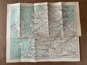
Antique map of Scotland Skye to Inverness 1909
£8.99
ApproximatelyEUR 10.63
Condition:
“Antique original, rough page edge. some foxing and discoloration, folds”
- Buy it nowAntique map of Scotland Skye to Inverness 1909
Oops! Looks like we're having trouble connecting to our server.
Refresh your browser window to try again.
Postage:
£3.50 (approx EUR 4.14) Royal Mail International Standard.
Located in: Horncastle, United Kingdom
Delivery:
Estimated between Thu, 15 May and Thu, 29 May
Returns:
14 days return. Buyer pays for return postage. If you use an eBay delivery label, it will be deducted from your refund amount.
Payments:
Shop with confidence
Seller assumes all responsibility for this listing.
eBay item number:297251046563
Item specifics
- Seller notes
- “Antique original, rough page edge. some foxing and discoloration, folds”
- Antique
- Yes
- Date Range
- 1950-1959
- Type
- Thematic Map
- Format
- Atlas Map
- Printing Technique
- Lithography
- Year
- 1909
- Original/Reproduction
- Antique Original
- Cartographer/Publisher
- John Bartholomew
- Country/Region
- Europe, Scotland
Item description from the seller
Seller business information
About this seller

Silicon Press
100% positive Feedback•2.2K items sold
Registered as a business seller
Popular categories from this shop
Seller Feedback (737)
- u***n (5120)- Feedback left by buyer.Past monthVerified purchaseI am in receipt of item
- a***a (787)- Feedback left by buyer.Past monthVerified purchaseArrived all OK thanks DA
- l***s (3342)- Feedback left by buyer.Past monthVerified purchaseClassic map in good condition apart from some foxing. Good value and good service from seller.
More to explore:
- Inverness-shire Antique Europe Sheet Maps,
- Antique European Maps & Atlases Inverness-shire,
- 1900-1909 Date Range Antique Railroad Maps,
- Antique Original 1900-1909 Date Range Antique Atlas Maps,
- Political Map 1900-1909 Date Range Antique Sheet Maps,
- 1900-1909 Date Range Antique Ordnance Survey Maps,
- 1900-1909 Date Range Antique Wall Maps,
- 1900-1909 Date Range County Map Antique Europe Atlas Maps,
- 1900-1909 Date Range Ordnance Survey Map Antique Folding Maps,
- 1900-1909 Date Range Antique World Maps & Atlases
Popular categories from this shop
Seller Feedback (737)
- u***n (5120)- Feedback left by buyer.Past monthVerified purchaseI am in receipt of item
- a***a (787)- Feedback left by buyer.Past monthVerified purchaseArrived all OK thanks DA
- l***s (3342)- Feedback left by buyer.Past monthVerified purchaseClassic map in good condition apart from some foxing. Good value and good service from seller.