Picture 1 of 8


Picture 1 of 8


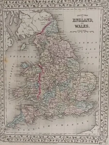
1873 Mitchell's Atlas County Map of England and Wales Authentic Hand-colored

US $100.00
ApproximatelyEUR 89.51
or Best Offer
Condition:
“Very good condition with only slight wear or browning mostly along the edges. THIS MAP IS VERY ”... Read moreAbout condition
Postage:
US $11.95 (approx EUR 10.70) Economy Shipping.
Located in: Swampscott, Massachusetts, United States
Delivery:
Estimated between Wed, 2 Oct and Mon, 7 Oct to 43230
Returns:
30 days return. Buyer pays for return postage.
Payments:
Shop with confidence
Seller assumes all responsibility for this listing.
eBay item number:326123130298
Item specifics
- Seller notes
- Date Range
- 1800-1899
- Type
- County Map
- Format
- Atlas Map
- Printing Technique
- Lithography
- Year
- 1873
- Cartographer/Publisher
- Samuel Augustus Mitchell
- Original/Reproduction
- Antique Original
- City
- London
- Country/Region
- Wales
- County
- Anglesey, Angus/Forfarshire, Antrim, Argyll, Avon, Ayrshire, Banffshire, Bedfordshire
Item description from the seller

Popular categories from this shop
Registered as a private seller
Thereby, consumer rights stemming from EU consumer protection law do not apply. eBay buyer protection still applies to most purchases.
Seller Feedback (1,540)
- o***c (52)- Feedback left by buyer.Past monthVerified purchaseGreat seller, would recommend
- l***- (235)- Feedback left by buyer.Past monthVerified purchaseExactly as described. Well packaged and fast shipping.
- e***e (51)- Feedback left by buyer.Past monthVerified purchaseGreat
More to explore:
- County Map Antique Atlas Maps,
- County Map Antique Atlas,
- County Durham County Map Antique Europe Atlas Maps,
- County Map Antique Europe Atlas Maps,
- Lithography County Map Antique Atlas Maps,
- John Bartholomew County Map Antique Atlas Maps,
- Lincolnshire County Map Antique Europe Atlas Maps,
- Devon County Map Antique Europe Atlas Maps,
- Huntingdonshire County Map Antique Europe Atlas Maps,
- London County Map Antique Europe Atlas Maps