Picture 1 of 8


Gallery
Picture 1 of 8


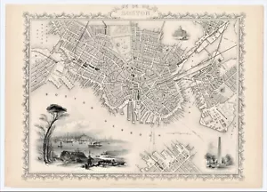
Antique Map "Boston" (U.S.A.) John Tallis, 1851
£260.00
ApproximatelyEUR 305.45
or Best Offer
Condition:
- Buy it nowAntique Map "Boston" (U.S.A.) John Tallis, 1851
Oops! Looks like we're having trouble connecting to our server.
Refresh your browser window to try again.
Postage:
£18.00 (approx EUR 21.15) International Tracked Postage.
Located in: London, United Kingdom
Delivery:
Estimated between Thu, 8 May and Wed, 14 May to 43230
Returns:
No returns accepted.
Payments:
Shop with confidence
Seller assumes all responsibility for this listing.
eBay item number:335614104028
Item specifics
- Date Range
- 1800-1899
- Antique
- Yes
- Type
- City Map
- US State
- Massachusetts
- Format
- Sheet Map
- Printing Technique
- Steel Engraving
- Year
- 1851
- Era
- 1800s
- Original/Reproduction
- Antique Original
- Cartographer/Publisher
- John Tallis - Rapkin
- City
- Boston
- Country/Region
- United States of America
Item description from the seller
Seller business information
CRN: 07952137

Popular categories from this shop
Seller Feedback (266)
- 0***p (87)- Feedback left by buyer.Past monthVerified purchaseOnly for my impatience to start reading the book, I had to disturb the impeccable packaging which I was admittedly totally in awe with. Perfect, thank you so much again.
- l***l (612)- Feedback left by buyer.Past monthVerified purchaseall good, as described.
- a***n (55)- Feedback left by buyer.Past monthVerified purchaseAs described. Shipped with great care. Loved he sent prominence along w it
More to explore:
- John Speed Antique County Maps,
- Boston Antique North America Wall Maps,
- Boston Antique North America Railroad Maps,
- Boston Antique North America City Maps,
- Boston Antique North America Atlas Maps,
- John Cary Antique County Maps,
- John Speed Antique Reproduction Antique County Maps,
- John Speed Antique Original Antique County Maps,
- John Ogilby Antique Maps, Atlases & Globes,
- John Bartholomew Antique Maps, Atlases & Globes
Popular categories from this shop
Seller Feedback (266)
- 0***p (87)- Feedback left by buyer.Past monthVerified purchaseOnly for my impatience to start reading the book, I had to disturb the impeccable packaging which I was admittedly totally in awe with. Perfect, thank you so much again.
- l***l (612)- Feedback left by buyer.Past monthVerified purchaseall good, as described.
- a***n (55)- Feedback left by buyer.Past monthVerified purchaseAs described. Shipped with great care. Loved he sent prominence along w it