Picture 1 of 3


Gallery
Picture 1 of 3


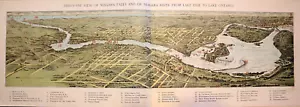
Bird's-Eye View - NIAGARA FALLS & NIAGARA RIVER from LAKE ERIE to LAKE ONTARIO
US $83.55
ApproximatelyEUR 73.96
or Best Offer
Was US $88.88 (6% off)
Condition:
“This map is not *new* or in *new* condition. It was printed in 1892. It is in good condition.”
- Buy it nowBird's-Eye View - NIAGARA FALLS & NIAGARA RIVER from LAKE ERIE to LAKE ONTARIO
Oops! Looks like we're having trouble connecting to our server.
Refresh your browser window to try again.
Postage:
Free USPS Ground Advantage®.
Located in: Schertz, Texas, United States
Delivery:
Estimated between Sat, 10 May and Fri, 16 May to 43230
Returns:
30 days return. Seller pays for return postage.
Payments:
Shop with confidence
Seller assumes all responsibility for this listing.
eBay item number:356564374814
Item specifics
- Seller notes
- “This map is not *new* or in *new* condition. It was printed in 1892. It is in good condition.”
- Fold
- Folded thin paper
- US State
- New York
- Printing Technique
- Lithography
- Year
- 1892
- S&H
- Free S&H USA - Calculated S&H Worldwide
- Canadian Province
- Ontario
- Size
- Approx. 5 1/2" x 16"
- Original/Reproduction
- 1892 Antique Original
- Country/Region
- United States of America
Item description from the seller
About this seller

MapHatter
99.7% positive Feedback•27K items sold
Registered as a private sellerThereby, consumer rights stemming from EU consumer protection law do not apply. eBay buyer protection still applies to most purchases.
Seller Feedback (9,513)
- 2***e (532)- Feedback left by buyer.Past monthVerified purchaseOnly challenge was shipping- took a couple days to leave the seller, then it was slow going after that. Just was anxious because there is a plot on the map from way back in my family. Great packaging- fair deal.
- 0***1 (315)- Feedback left by buyer.Past monthVerified purchaseDeal went well
- 2***i (637)- Feedback left by buyer.Past monthVerified purchaseSuperb map. Very pleased. Expertly packaged. Arrived in perfect condition. Highest recommendation for this seller +++++
More to explore:
- Antique North American Maps & Atlases Ontario,
- Ontario Antique North America Sheet Maps,
- Ontario Antique North America Atlas Maps,
- Ontario Lithography Antique North American Maps & Atlases,
- Antique North American Maps Ontario 1800-1899 Date Range Atlases,
- Antique River Maps,
- Antique Europe River Maps,
- London Antique Europe River Maps,
- Antique North America River Maps,
- 1800-1899 Date Range Antique River Maps
MapHatter
99.7% positive Feedback•27K items sold
Registered as a private sellerThereby, consumer rights stemming from EU consumer protection law do not apply. eBay buyer protection still applies to most purchases.
Seller Feedback (9,513)
- 2***e (532)- Feedback left by buyer.Past monthVerified purchaseOnly challenge was shipping- took a couple days to leave the seller, then it was slow going after that. Just was anxious because there is a plot on the map from way back in my family. Great packaging- fair deal.
- 0***1 (315)- Feedback left by buyer.Past monthVerified purchaseDeal went well
- 2***i (637)- Feedback left by buyer.Past monthVerified purchaseSuperb map. Very pleased. Expertly packaged. Arrived in perfect condition. Highest recommendation for this seller +++++