Picture 1 of 7


Gallery
Picture 1 of 7


Have one to sell?
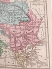
1866 Hand-Colored Map of "A Part of Europe" Turkey Italy+ Approx 11" x 9" #20839

US $19.25
ApproximatelyEUR 16.64
Condition:
“Antique original from 1866 Grammar School Geography Book. Maps will have foxing, tinting consistent ”... Read moreAbout condition
- Buy it now1866 Hand-Colored Map of "A Part of Europe" Turkey Italy+ Approx 11" x 9" #20839
Oops! Looks like we're having trouble connecting to our server.
Refresh your browser window to try again.
Postage:
US $4.47 (approx EUR 3.86) USPS Media MailTM.
Located in: Columbia, Tennessee, United States
Delivery:
Estimated between Thu, 13 Nov and Tue, 18 Nov to 94104
Returns:
30 days return. Buyer pays for return postage. If you use an eBay delivery label, it will be deducted from your refund amount.
Payments:
Shop with confidence
Seller assumes all responsibility for this listing.
eBay item number:356773472912
Item specifics
- Seller notes
- Date Range
- 1800-1899
- Type
- Geological Map
- Format
- Atlas Map
- Original/Reproduction
- Antique Original
- Cartographer/Publisher
- S.S. Cornell
- Country/Region
- Europe
Item description from the seller
Seller business information
About this seller

Bargain Hound USA
99.9% positive Feedback•61K items sold
Registered as a business seller
Seller Feedback (26,952)
- 7***s (356)- Feedback left by buyer.Past 6 monthsVerified purchaseBeautiful Lands end sweater, packaged with great care, mailed within an hour of my ordering, and pretty as described too. Just as I had hoped, it is so lovely and a wonderful value price. Thank you for this terrific EBAY transaction and super seller too!Lands' End Button Front Cardigan Sweater Lg Slv Red Sz M/P 10-12 #16950 (#297015331499)
- l***2 (60)- Feedback left by buyer.Past 6 monthsVerified purchaseThank you so much for the outstanding service - I greatly appreciate it! Excellent condition, as described; as well as excellent value, shipping, packaging!Columbia Omni Shield Pull On Pants Straight Leg 3 Pockets Gray Size L #16400 (#356820588684)
- h***5 (1943)- Feedback left by buyer.Past 6 monthsVerified purchaseAwesome seller fast shipping, great safe packaging items were just as described at a great price will definitely buy this sell again.Vintage 1990s GI Joe 12" Uniforms Clothes Dress Blues and more 17 pieces #21684 (#356268085703)
More to explore:
- Antique Europe Maps & Atlases,
- Antique Europe County Maps,
- Antique Europe Folding Maps,
- Topographical Map Antique Europe Folding Maps,
- Physical Map Antique Europe Atlas Maps,
- Nautical Map Antique Europe Sheet Maps,
- City Map Antique Europe Folding Maps,
- Political Map Antique Europe Atlas Maps,
- County Map Antique Europe Folding Maps,
- Nautical Map Antique Europe Folding Maps
Seller Feedback (26,952)
- 7***s (356)- Feedback left by buyer.Past 6 monthsVerified purchaseBeautiful Lands end sweater, packaged with great care, mailed within an hour of my ordering, and pretty as described too. Just as I had hoped, it is so lovely and a wonderful value price. Thank you for this terrific EBAY transaction and super seller too!Lands' End Button Front Cardigan Sweater Lg Slv Red Sz M/P 10-12 #16950 (#297015331499)
- l***2 (60)- Feedback left by buyer.Past 6 monthsVerified purchaseThank you so much for the outstanding service - I greatly appreciate it! Excellent condition, as described; as well as excellent value, shipping, packaging!Columbia Omni Shield Pull On Pants Straight Leg 3 Pockets Gray Size L #16400 (#356820588684)
- h***5 (1943)- Feedback left by buyer.Past 6 monthsVerified purchaseAwesome seller fast shipping, great safe packaging items were just as described at a great price will definitely buy this sell again.Vintage 1990s GI Joe 12" Uniforms Clothes Dress Blues and more 17 pieces #21684 (#356268085703)