
Picture 1 of 3
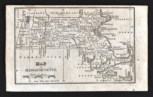


1830 Nathan Hale Map - Massachusetts - Boston Plymouth Cape Cod Salem Worcester
Condition:
“Fair, it measures approximately 3 3/4 by 6 inches on a 4 1/2 by 7 1/4" page (11x18cm), there is ”... Read moreAbout condition
Offer ends in: 3d 6h
Price:
US $39.99
ApproximatelyEUR 36.98
Was US $49.99
Save US $10.00 (20% off)
- Buy it now1830 Nathan Hale Map - Massachusetts - Boston Plymouth Cape Cod Salem Worcester
Best Offer:
Postage:
Located in: Fairview, Pennsylvania, United States
Delivery:
Estimated between Mon, 3 Jun and Wed, 5 Jun to 43230
Returns:
Payments:
Shop with confidence
Seller information
Registered as a business seller
Seller assumes all responsibility for this listing.
eBay item number:364599307688
Item specifics
- Seller notes
- Cartographer/Publisher
- Nathan Hale
- Printing Technique
- Copper Plate
- Original/Reproduction
- Antique Original
- Format
- Atlas Map
- Type
- Political Map
- Year
- 1830
- US State
- CT, MA, ME, NH, RI, VT, Massachusetts
- Date Range
- 1800-1899
- City
- Boston
- Country/Region
- United States of America
Item description from the seller
Seller assumes all responsibility for this listing.
eBay item number:364599307688
Postage and packaging
| Free P&P on orders of 5 or more eligible items from c574778. |
| Free P&P on each additional eligible item you buy from c574778. |
Item location:
Fairview, Pennsylvania, United States
Posts to:
Afghanistan, Albania, Algeria, American Samoa, Andorra, Angola, Anguilla, Antigua and Barbuda, Argentina, Armenia, Aruba, Australia, Austria, Azerbaijan Republic, Bahamas, Bahrain, Bangladesh, Belarus, Belgium, Belize, Benin, Bermuda, Bhutan, Bolivia, Bosnia and Herzegovina, Botswana, Brazil, British Virgin Islands, Brunei Darussalam, Bulgaria, Burkina Faso, Burundi, Cambodia, Cameroon, Canada, Cape Verde Islands, Cayman Islands, Central African Republic, Chad, Chile, China, Colombia, Comoros, Cook Islands, Costa Rica, Cyprus, Czech Republic, Côte d'Ivoire (Ivory Coast), Democratic Republic of the Congo, Denmark, Djibouti, Dominica, Dominican Republic, Ecuador, Egypt, El Salvador, Equatorial Guinea, Eritrea, Estonia, Ethiopia, Falkland Islands (Islas Malvinas), Fiji, Finland, France, Gabon Republic, Gambia, Georgia, Germany, Ghana, Gibraltar, Greece, Greenland, Grenada, Guam, Guatemala, Guernsey, Guinea, Guinea-Bissau, Guyana, Haiti, Honduras, Hong Kong, Hungary, Iceland, India, Indonesia, Iraq, Ireland, Israel, Italy, Jamaica, Japan, Jersey, Jordan, Kazakhstan, Kenya, Kiribati, Kuwait, Kyrgyzstan, Laos, Latvia, Lebanon, Lesotho, Liberia, Liechtenstein, Lithuania, Luxembourg, Macau, Macedonia, Madagascar, Malawi, Malaysia, Maldives, Mali, Malta, Marshall Islands, Mauritania, Mauritius, Mayotte, Mexico, Micronesia, Moldova, Monaco, Mongolia, Montenegro, Montserrat, Morocco, Mozambique, Namibia, Nauru, Nepal, Netherlands, Netherlands Antilles, New Zealand, Nicaragua, Niger, Nigeria, Niue, Norway, Oman, Pakistan, Palau, Panama, Papua New Guinea, Paraguay, Peru, Philippines, Poland, Portugal, Puerto Rico, Qatar, Republic of Croatia, Republic of the Congo, Romania, Rwanda, Saint Helena, Saint Kitts-Nevis, Saint Lucia, Saint Pierre and Miquelon, Saint Vincent and the Grenadines, San Marino, Saudi Arabia, Senegal, Serbia, Seychelles, Sierra Leone, Singapore, Slovakia, Slovenia, Solomon Islands, Somalia, South Africa, South Korea, Spain, Sri Lanka, Suriname, Svalbard and Jan Mayen, Swaziland, Sweden, Switzerland, Taiwan, Tajikistan, Tanzania, Thailand, Togo, Tonga, Trinidad and Tobago, Tunisia, Turkey, Turkmenistan, Turks and Caicos Islands, Tuvalu, Uganda, United Arab Emirates, United Kingdom, Uruguay, Uzbekistan, Vanuatu, Vatican City State, Vietnam, Virgin Islands (U.S.), Wallis and Futuna, Western Sahara, Western Samoa, Worldwide, Yemen, Zambia, Zimbabwe
Excludes:
Barbados, French Guiana, French Polynesia, Guadeloupe, Libya, Martinique, New Caledonia, Reunion, Russian Federation, Ukraine, Venezuela
| Postage and packaging | To | Service | Delivery*See Delivery notes |
|---|---|---|---|
| US $4.99 (approx EUR 4.61) | United States | Standard Delivery (USPS Ground Advantage®) | Estimated between Mon, 3 Jun and Wed, 5 Jun to 43230 |
| US $8.99 (approx EUR 8.31) | United States | Express Delivery (USPS Priority Mail®) | Estimated between Mon, 3 Jun and Wed, 5 Jun to 43230 |
| Dispatch time |
|---|
| Will usually dispatch within 1 working day of receiving cleared payment. |
| Taxes |
|---|
| Taxes may be applicable at checkout. Learn moreLearn more about paying tax on eBay purchases. |
Sales tax for an item #364599307688
Sales tax for an item #364599307688
Seller collects sales tax/VAT for items dispatched to the following states:
| County | VAT rate |
|---|
Returns policy
| After receiving the item, cancel the purchase within | Refund will be given as | Return postage |
|---|---|---|
| 30 days | Money back | Seller pays for return postage |
The seller is responsible for return postage costs.
| Return policy details |
|---|
| Returns accepted |
Most Buy It Now purchases are protected by the Consumer Rights Directive, which allow you to cancel the purchase within seven working days from the day you receive the item. Find out more about your rights as a buyer and exceptions.
Payment details
Payment methods

Registered as a business seller
Seller Feedback (19,381)
d***e (4)- Feedback left by buyer.
Past month
Verified purchase
All good.
w***a (6001)- Feedback left by buyer.
Past month
Verified purchase
Very nice. +++++++++
h***s (170)- Feedback left by buyer.
Past month
Verified purchase
Marvellous
More to explore:
- Antique North American Maps & Atlases Massachusetts,
- Antique North American Maps & Atlases Salem,
- Massachusetts Antique Original Antique North American Maps & Atlases,
- Boston Antique North America Wall Maps,
- Boston Antique North America Railroad Maps,
- Geological Map Antique Sheet Maps,
- Ordnance Survey Map Antique Europe Folding Maps,
- County Map Antique Wall Maps,
- County Map Antique Folding Maps,
- Ordnance Survey Map Antique Folding Maps