Picture 1 of 5


Gallery
Picture 1 of 5


Have one to sell?
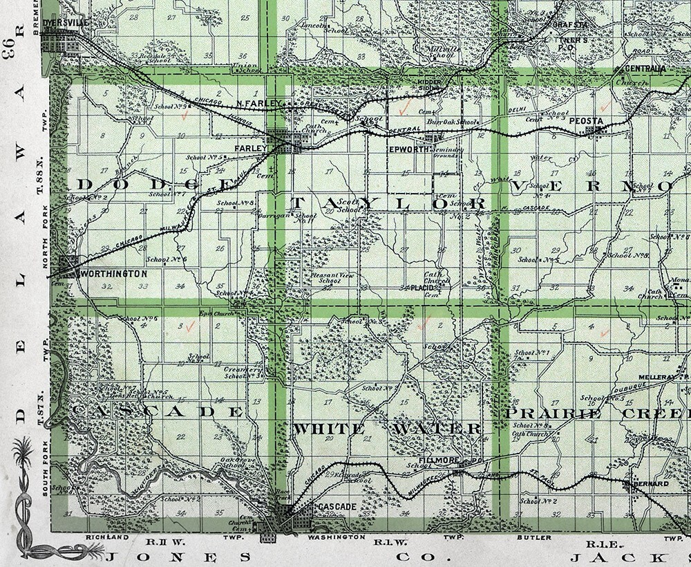
1904 Huebinger Iowa Map Dubuque County Dyersville Cascade Balltown Farley IA

US $119.20
ApproximatelyEUR 101.85
Was US $149.00 (20% off)
Condition:
“See Description and Pics below. 15x18 inch page. Original map, not a reproduction!”
Offer ends in: 3d 3h
- Buy it now1904 Huebinger Iowa Map Dubuque County Dyersville Cascade Balltown Farley IA
Oops! Looks like we're having trouble connecting to our server.
Refresh your browser window to try again.
Postage:
US $4.99 (approx EUR 4.26) USPS Ground Advantage®.
Located in: Fairview, Pennsylvania, United States
Delivery:
Estimated between Fri, 3 Oct and Fri, 10 Oct to 94104
Returns:
30 days return. Seller pays for return postage.
Payments:
Shop with confidence
Seller assumes all responsibility for this listing.
eBay item number:365380453967
Item specifics
- Seller notes
- “See Description and Pics below. 15x18 inch page. Original map, not a reproduction!”
- Date Range
- 1900-1909
- Type
- County Map
- Format
- Atlas Map
- US State
- AR, IA, KS, LA, MO, NE, Iowa
- Printing Technique
- Lithography
- Year
- 1904
- Original/Reproduction
- Antique Original
- Cartographer/Publisher
- Huebinger
- Country/Region
- United States of America
Item description from the seller
Seller business information
About this seller

Lake Erie Antique Maps and Prints
99.7% positive Feedback•39K items sold
Registered as a business seller
Seller Feedback (19,965)
- d***h (468)- Feedback left by buyer.Past monthVerified purchaseExcellant transaction!
- eBay 自動留下信用評價- Feedback left by buyer.Past month訂單成功完成 — 物品享追蹤服務且準時送達
- eBay 自動留下信用評價- Feedback left by buyer.Past month訂單成功完成 — 物品享追蹤服務且準時送達
More to explore:
- Antique North American Maps & Atlases Iowa,
- Iowa Antique North America City Maps,
- Antique County Maps,
- County Durham County Map Antique Europe Atlas Maps,
- County Durham County Map Antique Europe Sheet Maps,
- Norfolk Antique County Maps,
- County Map Antique Europe Atlas Maps,
- Yorkshire Antique Europe County Maps,
- Emanuel Bowen Antique County Maps,
- Herman Moll Antique County Maps
Lake Erie Antique Maps and Prints
99.7% positive Feedback•39K items sold
Registered as a business seller
Seller Feedback (19,965)
- d***h (468)- Feedback left by buyer.Past monthVerified purchaseExcellant transaction!
- eBay 自動留下信用評價- Feedback left by buyer.Past month訂單成功完成 — 物品享追蹤服務且準時送達
- eBay 自動留下信用評價- Feedback left by buyer.Past month訂單成功完成 — 物品享追蹤服務且準時送達